The eastern Athabasca Basin region has been the hub of uranium exploration and mining for the past 50 years and is home to three licensed uranium mills and several high-grade uranium deposits (Figure 1). Standard Uranium has strategically staked 3 different projects in the region and is targeting high-grade unconformity-related mineralization on the 100%-owned Atlantic, Canary, and Ascent projects (Figure 2). The Canary and Ascent Projects are located 40 km north east of the Company’s Atlantic project near the eastern edge of the Athabasca Basin.
The northern portion of the eastern Athabasca Basin uranium district where the projects are located is underexplored relative to the rest of the eastern Athabasca region, and all 3 projects contain prospective and relatively shallow geophysical targets (Figure 3). The Company views the eastern Athabasca projects as an excellent chance to add value and increase the chances for a new discovery in areas that have fundamentally strong geological conditions for uranium and have positive historical exploration results. In 2022, the Company completed a ground gravity survey on the Atlantic project, a ground DCIP resistivity survey on the Canary project, and a high-resolution airborne TDEM survey on the Ascent project. High-priority target areas have been identified, and the eastern Athabasca projects will require very little additional exploration before drill testing uranium target zones.
Standard Uranium holds a 100%-interest in the Atlantic project, which consists of 6 mineral claims totalling 2,176 hectares (Figure 2).
The property covers 6.5 km of an 18 km long, east-west trending conductive exploration trend, located due west of IsoEnergy’s Hurricane Zone (Figure 4). Additionally, depth to the sub-Athabasca nonconformity is known to be between 230 and 485 metres from the surface.
Historical Drilling by Cameco in 1992 (hole BE-04; Figure 4) encountered up to 0.06% U3O8 over 0.5 metres in the sandstone, near the unconformity. Additionally, the hole encountered elevated uranium and nickel, and illite and chlorite alteration in the lower 10 metres of sandstone.
Follow-up drilling by Denison Mines in 2012 (Hole BL12-13), next to BE-04, encountered a fault-zone located 130 metres above the sandstone that contains 10.2 ppm uranium, 786 ppm lead, and 2,270 ppm zinc and other base-metals over 0.1 metre. Additionally, a composite sample of the basal 13.4 metres of sandstone returned 477 ppm uranium.
At the western claim block, drilling by Denison Mines in 2016 (Hole BL16-32) encountered 342 ppm uranium over 0.5 metres at the base of the sandstone.
The Canary project comprises 2 mineral dispositions totalling 7,303 hectares (Figure 2). The project was acquired via staking in July 2020, and Standard Uranium holds a 100%-interest in the property.
Historical airborne electromagnetic work between 1993 and 2006 identified 3 main conductive systems (Figure 5) that represent trends of graphitic metasedimentary rocks, which are prospective host rocks for uranium mineralization. Furthermore, ground EM and IP surveys have confirmed two prospective target areas on the property related to structural disruptions of the conductive corridors. In addition, depth to the Athabasca-basement nonconformity is known to be between 84 and 230 metres from the surface on the project, resulting in shallow drill target depths.
Historical drill-hole CRK-137 (Figure 5) identified highly anomalous uranium enrichment near the unconformity with 10 ppm uranium over 7.4 metres in systematic composite sampling of the sandstone, and strong hydrothermal alteration was observed throughout the interval. Within this zone, a discrete 0.5 m sub-interval returned 103.1 ppm uranium; and a 1.0 m interval in the graphitic metasediments immediately below the unconformity returned 200 ppm uranium.
Only one of the three conductive targets on the property has been tested by drilling, and results are considered highly anomalous. Exploration at the Canary project is early stage, and it remains highly prospective for unconformity-related and basement hosted uranium mineralization. The ground-based DCIP resistivity survey completed in 2022 has defined high-priority drill targets for an inaugural drill program on the project by the Company.
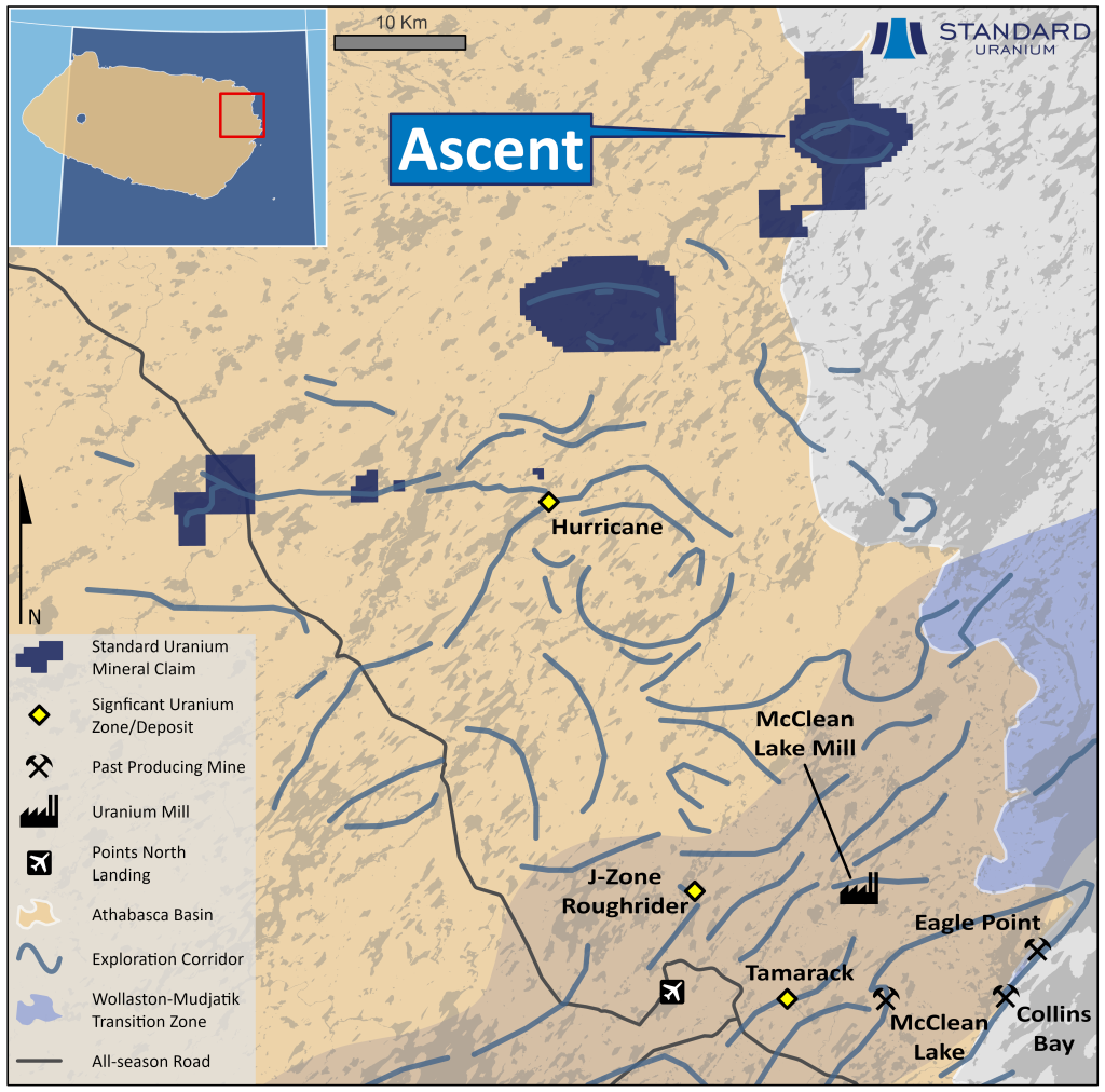
Standard Uranium holds a 100%-interest in the Ascent project which straddles the eastern boundary of the Athabasca Basin (Figure 2). The project consists of a single mineral disposition totalling 3,737 hectares.
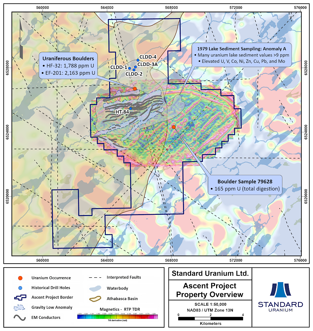
As the property lies on the edge of the Basin, depth to the sub-Athabasca unconformity is known to be approximately 50 metres from surface at maximum, while the eastern portion of the project has no Athabasca sandstone cover.
Historical airborne EM work in 1979 and 2006 has identified one large, 6-km long and 3-km wide conductive corridor with numerous target areas related to potential cross structures (Figure 6). In the early 1980s the area was covered with ground EM surveys which confirmed the airborne targets.
Additionally, a 1979 lake sediment sampling program identified a very high-priority Radon-U-Co-Ni-Zn-Mo-Pb-V anomaly located immediately above the conductive target (Figure 6). Only one drill hole (HT-84; Figure 6), completed in 1984, has tested the extensive conductive corridor with 6 km of strike length remaining un-tested and ready for further exploration.
Regional prospecting by historical operators also identified uranium enrichment in basement rocks located east of the Athabasca Basin edge, which support the exploration model for shallow sandstone and basement hosted uranium on the property. The high-resolution TDEM survey completed in 2022 has outlined shallow geophysical conductors on the project, defining several priority drill targets for the Company’s inaugural drill program on the project.
The current exploration model for the Ascent project is analogous to that of the J-Zone and Roughrider deposits, that are located proximal to a similar airborne EM target that has dimensions of roughly 2-km long by 1-km wide. The Ascent EM target is interpreted by the Company to represent a shallow-dipping conductive system and will be the focus of future exploration programs, drawing on the analogy of the J-Zone and Roughrider uranium deposits.
Disclosure of Technical and Scientific Information
Except as otherwise noted herein, Sean Hillacre, MSc. P.Geo., Standard Uranium’s VP Exploration, has reviewed and approved the scientific and technical information contained in this website. Mr. Hillacre is a Qualified Person within the meaning of Canadian Securities Administrator’s National Instrument 43-101.