Atlantic Project
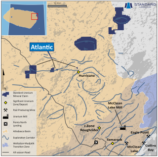
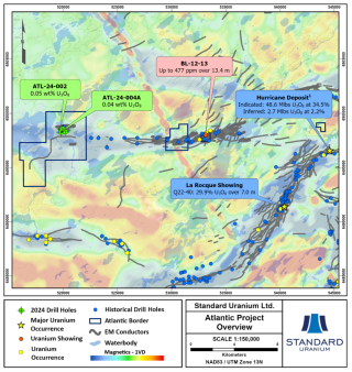
The Atlantic project consists of 6 mineral dispositions totalling 3,013 hectares, strategically located due west of IsoEnergy’s Hurricane Zone. The project was acquired via staking in March 2019, and Standard Uranium holds a 100%-interest in the property.
The property covers 6.5 km of an 18 km long, east-west trending conductive exploration trend which hosts numerous uranium occurrences. Depth to the sub-Athabasca nonconformity is known to be between 230 and 485 metres from the surface across the project.
Historical drilling by Cameco in 1992 (Hole BE-04) encountered up to 0.06% U3O8 over 0.5 metres in the sandstone, proximal to the unconformity. Additionally, the hole encountered elevated uranium and nickel, as well as illite and chlorite alteration in the lower 10 metres of sandstone.
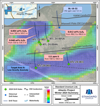
Follow-up drilling by Denison Mines in 2012 (Hole BL12-13), next to BE-04, encountered a fault-zone located 130 metres above the sandstone that contains 10.2 ppm uranium, 786 ppm lead, and 2,270 ppm zinc over 0.1 metre. Additionally, a composite sample of the basal 13.4 metres of sandstone returned 477 ppm uranium. At the western claim block, drilling by Denison Mines in 2016 (Hole BL16-32) identified 342 ppm uranium over 0.5 metres at the base of the sandstone.
In June 2022, the Company completed a high-resolution ground gravity survey on the western claim block to identify subsurface density anomalies, potentially representing significant alteration zones.
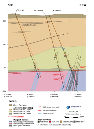
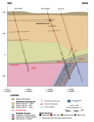
The inaugural winter 2024 drill program comprised 3,316 metres of diamond drilling across 5 drill holes on the western claim block. Inaugural drilling intersected the key characteristics of a uranium-bearing mineralized system in previously untested “Target Area A”, confirming the presence of a significant graphitic fault system in the basement rock linked to uranium mineralization and prospective hydrothermal alteration at the unconformity and in the basement rock. The drill program was designed to follow up on highly anomalous uranium results returned from drill hole BL-16-32, in addition to testing the newly outlined gravity lows defined by the 2022 ground survey. On the western Atlantic claim block, drilling by Denison Mines in 2016 (Hole BL-16-32) identified 342 ppm uranium over 0.5 metres at the base of the sandstone, just north of Target Area A. Winter drilling was focused in Target Area A which is defined by a 1,400-metre x 850-metre density-low anomaly coinciding with stacked EM conductors and an interpreted regional fault. Figure 2 highlights winter 2024 drilling focused on testing the 3D density anomaly target at the unconformity linked to basement EM conductors and interpreted fault trends.
Maps & Figures
Disclosure of Technical and Scientific Information
Except as otherwise noted herein, Sean Hillacre, MSc. P.Geo., Standard Uranium’s VP Exploration, has reviewed and approved the scientific and technical information contained in this website. Mr. Hillacre is a Qualified Person within the meaning of Canadian Securities Administrator’s National Instrument 43-101.

